


New Online Map of Public Lands in Washington
Posted July 19, 2014 at 5:05 am by Tim Dustrude
State Unveils New Online Map of Public Lands in Washington
The Recreation and Conservation Office (RCO) announced a new online, interactive map of natural resource and recreation lands owned by government agencies.
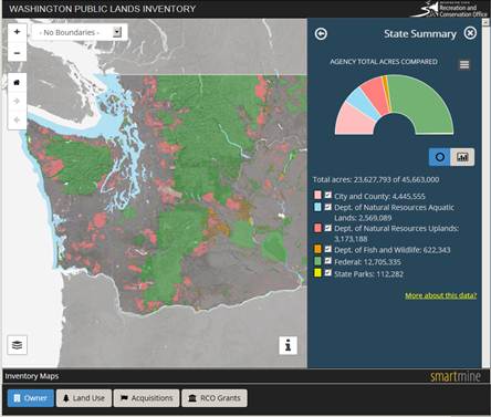
The statewide map, located at this link, allows people to click on a location and learn which agency owns the land, the number of acres, the main use of the land and the cost of acquisition if acquired within the past 10 years. Information is provided on land owned by cities, counties, the federal government and three state agencies – the State Parks and Recreation Commission, the Department of Fish and Wildlife and the Department of Natural Resources. The public can search government-owned parcels by owner and principal land use. In addition, details about acquisition grants from RCO are linked to the interactive map.
“This is the first time public lands information has been brought together in an electronic format easily accessible by the public,” said Kaleen Cottingham, RCO director. “This map will be very useful to people who want to see what’s happening in their communities and to government agencies for planning purposes. It takes the mystery out of government land purchases and puts them on the Web for all to see and use.”
RCO was tasked by the state Legislature in 2013 to provide an inventory of lands in Washington owned by federal, state and local governments. In the past, these public land inventories were printed documents.
Partners in the project included RCO, University of Washington’s School of Environmental and Forest Sciences, Department of Natural Resources, Department of Fish and Wildlife, the State Parks and Recreation Commission and contractor GeoEngineers.
“This project created a challenge to take complex information and present it in an intuitive way,” said Scot McQueen, chief strategy officer for SmartMine at GeoEngineers, Inc., which developed the web application. “We tried to create something that people would get excited about using and that still would give them detailed information. The end design is elegant and easy-to-understand.”
The Legislature also tasked RCO with making recommendations on how to maintain this inventory in the future. The report can be found at this link (PDF).
You can support the San Juan Update by doing business with our loyal advertisers, and by making a one-time contribution or a recurring donation.
Categories: Around Here
No comments yet. Be the first!
By submitting a comment you grant the San Juan Update a perpetual license to reproduce your words and name/web site in attribution. Inappropriate, irrelevant and contentious comments may not be published at an admin's discretion. Your email is used for verification purposes only, it will never be shared.