


Mapping the San Juans Redux
Posted August 11, 2015 at 5:38 am by Tim Dustrude
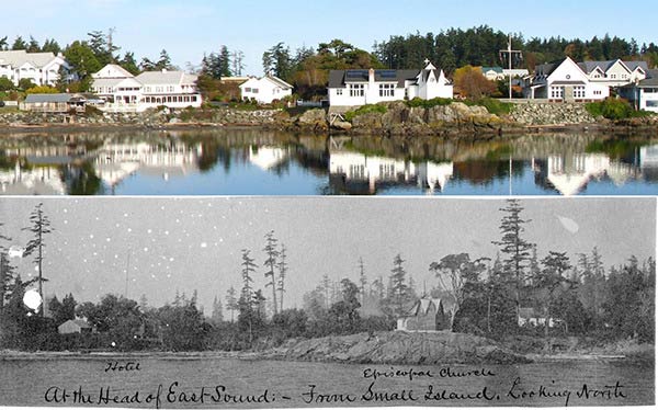
Mapping the San Juans – Contributed images
Join Boyd Pratt, Doug McCutchen, and Mike Vouri for a reprise and update of their evening of viewing 1890’s images of the San Juan Islands by the U.S. Coast Survey’s John Gilbert, contrasted with photographs taken from the same perspective today.
Vouri will open the discussion with a look at the first survey of the islands by the Coast Survey’s naval assistant, Lt. Cmdr. James Alden, and surveyor and map maker George Davidson operating from the U.S. Coast Steamer Active from 1853-1860. Pratt will follow with insights on Gilbert’s land-use T-sheets. McCutchen will then present a series of slides that capture from the same perspective today the sites of Gilbert’s images.
Wednesday, August 19, from 7:00 to 8:30 pm at the San Juan Island Grange
Please contact Mike Vouri at (360) 378-2240, ext. 2227 or email Mike_Vouri@nps.gov for more information.
You can support the San Juan Update by doing business with our loyal advertisers, and by making a one-time contribution or a recurring donation.
Categories: Around Here
No comments yet. Be the first!
By submitting a comment you grant the San Juan Update a perpetual license to reproduce your words and name/web site in attribution. Inappropriate, irrelevant and contentious comments may not be published at an admin's discretion. Your email is used for verification purposes only, it will never be shared.