


Surface Water in a Subarctic Desert
Posted June 10, 2020 at 6:16 am by Tim Dustrude
FREEZER BURNED: Tales of Interior Alaska is a new regular column on the San Juan Update written by Steve Ulvi…
Nearly every molecule of water that now covers 70% of our planet was spewed in awesome volcanic eruptions or carried frozen in asteroids or comets that pummeled a lifeless earth for eons.
Any given water molecule has surely been recycled through untold evaporation/precipitation cycles since an early atmosphere formed around 4,200,000,000 years ago. Suffice it to say; our water is very old.
Being a vital substance for life, any part of any drop of water you drink today could have coursed through the steamy bio-digester gut of a Woolly Mammoth or maybe been pumped to the top of a 300-foot redwood tree or perhaps sipped by a Neanderthal child in Spain. Use your imagination. So, there is more than a hint of truth in the old saying that cheap beer tastes like it “has been through a horse”.
Water in northern climes is a relentless shape-shifter; ice, vapor and liquid. A continental subarctic climatic zone is a swath of forest geography utterly dominated by winter. A dry, persistent winter that arrives with an attitude after just a few weeks of autumnal glory. Winter has been a predictable and stern master of all that lives in the geography of the enormous Yukon River drainage. If the climatic story of a year were in 12 chapters, like our calendar time, then below freezing temperatures occur in over 8 months with the other three seasons cram into 4 months. At higher elevations we can say that summer is just a sweet lie.
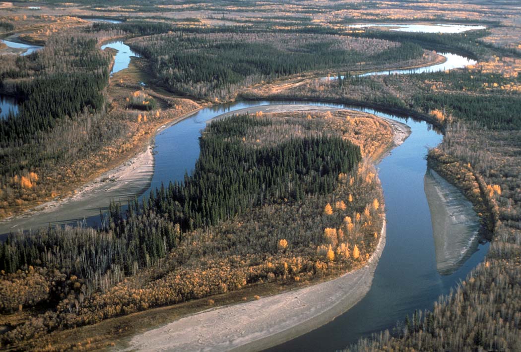
The Yukon River weaves 1,250 miles westerly across the bulge of Alaska but originates 800 miles further into the adjacent socialist territories of Hockey Land, ay? About now the water at that border might be running at about 250,000 cubic feet per second. With spring rainfall maybe even more. The roiling water carries so much silt and White River glacial flour that you can easily hear it scratch an aluminum hull like the output of a low volume Geiger-counter.
The extreme nature of that climate is best described as a “meteorological paradox”. Such an extreme range of annual temperatures (an eye-popping span of around 150 degrees F most years) can only occur in regions far from moderating oceanic warmth.
The geo-physiographic realities of the subarctic Alaska create some ironic conditions that a person from southern climes might not imagine. One of those enigmas is that there are great expanses of surface water, not unusual at lower elevations, in what can be defined as a semi-arid climatic region.
Like here, there is also a powerful rain shadow in play. On steroids! The slow, but inexorably rising 650-mile arc of the Alaska Range (pushing up at finger nail growth speed), where many peaks stab nearly three miles into the sky, is anchored by the Denali massif at 20,310 feet. The granite pluton of that range is part of the Pacific Ring of Fire and a source of many earthquakes. It also provides a textbook barrier to moist fronts blasting in from the Gulf of Alaska and dries the air entering the Interior.
Fairbanks is several hundred miles from the nearest salt water of the Pacific. Average annual precipitation there is just under 12 inches with nearly a quarter of that arriving as rain in the wettest month of the year, August. Much of the vast low elevation terrain of the basin comes in with similar numbers. The textbook definition of a desert (with particular geographic qualifiers) is 10 inches of annual precipitation or less.
Much of the vast Interior of Alaska is verdant in the dry summer months of June and July, with plenty of surface water in uncountable rivers, creeks, lakes, sloughs and muskeg bogs. Flying into the sun on a windless, late spring afternoon over the Yukon Flats in the heart of the Interior, makes it seem that a reflective mirror of golden water is everywhere.
Much of the Interior is underlain by depths of up to hundreds of feet of frozen parent ground, that absent removal of insulating surface vegetation may be only thawing under the midnight sun in an “active layer” to a depth of a foot or two before re-freezing in early winter. It has been this way for a very, very long time. But these vast areas of permafrost prevent drainage and create the green, watery landscapes that by the numbers is actually a semi-arid biome.
This creates some interesting surface waters: some lakes have no outlets, creeks and rivers cutting through permafrost soils all have a tannin “tea color” in summer, glacial rivers run grey with a colloidal suspension of flour-size particles of ground rock, while very few waters run clear, except high in the mountains where montane glaciers no longer remain. It is rare to find clear spring waters for immediate, untreated drinking.
In the 1960s many a big idea, no matter how loosely tethered to reality, were spawned based upon the notion that the relatively unpeopled expanse of wild Alaska was perfect for massive geographic alteration projects. For the dominant white culture of America, brimming with confidence after WWII technological achievements, activities of this kind were most easily rolled out where indigenous peoples lived and lacked sovereign powers and homeland ownership.
If you are of a certain age, numerous U.S. above ground blasts from Bikini Atoll in the Marshall Islands moved on to Amchitka Island, Alaska before test ban treaties finally moved detonations underground in the American desert. Over thirteen harrowing days in October of 1962, the Cuban Missile Crisis aroused images of monstrous expanding mushroom clouds while we students practiced ducking under flimsy school desks.
Prior to those unprecedented above ground blasts, that were larger than Hiroshima or Nagasaki by scales of magnitude, was the cockamamie idea (conjured by a cadre of elite nuclear physicists bent on finding practical uses in order to continue lucrative contracts for weapons programs) to use five nukes to excavate a harbor near very remote Pt. Hope, Alaska on the fringe of the continent.
In the latter stages of expedited research and planning a cabin full of uppity conservationists in Fairbanks, a handful of University of Alaska biologists, and the village leaders of Pt. Hope, just 30 miles from ground zero, together pulled down the curtain of double talk and obfuscation to reveal the deathly insanity of the project. A silver lining was that the controversy ushered in the yet-to-come era of federal environmental impact analyses, created a potent native-environmentalist alliance, and birthed the Tundra Times, a newspaper by and for Native Alaskans.
Even if we narrow the perspective some, to include only the most hair-brained schemes for the Alaska Interior, the military-industrial hubris of that era, really not so long ago, is enough to boggle the contemporary mind. And then there are the machinations of headline-grabbing Alaska politicians as the 800-mile Trans Alaska Oil Pipeline, a breathtaking engineering feat in its own right, became a reality in the 1970s. A real 48inch steel “pipe dream” come true. But the “unholy alliance” of environmentalists and Alaska Natives coalesced again with clout to become a real force to be reckoned with as the Great Partitioning of Alaska unfolded in the late 1970s.
There were always politicians wanting to hog the headlines touting fanciful schemes because Alaskans think BIG. Much more grandiose than pissant Texas. The catchy tee shirt and bumper stickers often became available before any pertinent research was completed. Or even begun. Make way for the grand experiment! The good Inupiat villagers of Pt. Hope, who harvested caribou that grazed on lichens that absorbed radiation fallout, were not even informed that they would be part of a grand experiment with the fickle genie of atomic fission to carve out a harbor that no one wanted in a traditional caribou hunting valley.
Well, all this freshwater of the Yukon drainage coursing to the Bering Sea, has not gone unnoticed by similar schemers with landscape-altering plots and unafraid to “play God” as long as the federal cash spigots could be turned open while rational public concerns were deftly side-stepped and dismissed.
How about reversing the flow of the age-old Tanana and Yukon Rivers using atomic explosions to excavate new channels in order to reverse the natural flow completely and turn it south? Nuclear reactors would power massive pumps to get all that “wasted” water down to the lower-48.
Governor Wally Hickel (Secretary of the Interior under Nixon and twice Governor of Alaska) in 1991 tried to dust off his dreams from the mid-60s about construction of a 1,400-mile undersea pipeline to send freshwater to California from Alaska rivers flowing into the Pacific. As any rational person would predict, the economics, environmental issues, and technical challenges eventually deflated this really bad idea before it went anywhere. Wally Hickel also invited the nuclear establishment to use the North Slope of Alaska for further blasts, but thankfully without success.
More on those instances of Alaska-scale hubris (like open air testing of thousands of weapons of mass destruction containing bacteriological agents, VX and mustard gas south of Fairbanks) at another time. Let’s get back to the Yukon, surface water and the vaunted Yukon Flats. You could say that the Flats, today mostly encompassed by a huge national wildlife refuge and native owned lands that were a direct legislative result of establishing the pipeline corridor, are the ecologic and geographic “heart” of the Interior region.
Travelling through the Flats in summer can be less like adventure and more like an unpleasant test of resolve. The skeets and other hungry bugs are legendary, the archipelago of endless islands, invisible sand and gravel bars, lack of geographic reference, and changing channels in a slowed current can be a kind of wilderness purgatory.
As the Project Chariot boondoggle ignominiously died in the early 1960s another mega-project, again a monstrously destructive “solution” for a non-existent and much exaggerated “problem”, took center stage in Alaska. The Rampart Dam Project on the middle Yukon River. Slated to become one of the largest gravity dams in the world (like Grand Coulee in WA) it was already costing US taxpayers millions in the late 1950s as the Army Corps of Engineers quietly planned. Drawn to be over 500 feet tall and span 1,400 feet, construction would require more than 20 million cubic yards of concrete and fill materials. Never mind that at that time that the narrow two-lane road ended just north of Fairbanks and the Alaska Railroad terminated in the yards in Fairbanks. Building northerly rails and highways up to the Rampart site would be part of the construction cost in order to get the building materials there.
The reservoir (once filled after 30 years or so) would be larger than Lake Eyrie at 270 miles long and up to 80 miles wide and 400 feet deep. Seven historic Athapaskan villages would be completely inundated by hundreds of feet of reservoir. Some of the most hyperbolic rhetoric in support of the dam made clear the colossal ignorance of ecology and complete disdain for aboriginal inhabitants and the large salmon runs upon which they depended.
Alaska Senator Ernest Gruening told audiences that “scenically it is zero…” and “nothing but a vast wasteland…notable chiefly for swarming clouds of mosquitos”. When asked about the 1,200 residents of those seven villages he said that it was a region “as worthless from the standpoint of human habitation as any that can be found on earth”.
The scheme was eventually touted by Alaska senators, big business and even both Nixon and Kennedy in the presidential election of 1960. The projected need was an unabashed fairy tale that the expanding population of Alaska and associated heavy industry would require an unprecedent amount of electrical generation from the middle of nowhere.
The highly effective and energized native-environmentalist coalition was already warmed up and ready for a fight. They sharpened their counter arguments about native homeland, fish and wildlife production and helped expose the smoke and mirrors and fuzzy math. In the late 1960s they finally helped drive a silver stake into the ill-conceived plan by forcing federal analysts to seriously question possible federal interests and massive tax payer expenditures over decades, in a frigid place far from power markets.
(coming up…The Odds are Good that the Goods are Odd)
You can support the San Juan Update by doing business with our loyal advertisers, and by making a one-time contribution or a recurring donation.
Categories: Environment, Freezer Burned, Lifestyle, People
One comment:
One comment...
Once again, Steve Ulvi has brought us Alaskan insights and history, and all creatively narrated with his sharp and imaginative verbiage. My thanks, Steve! I look forward to your next installment!
By submitting a comment you grant the San Juan Update a perpetual license to reproduce your words and name/web site in attribution. Inappropriate, irrelevant and contentious comments may not be published at an admin's discretion. Your email is used for verification purposes only, it will never be shared.