


Missing Mountain
Posted July 3, 2019 at 11:27 am by Tim Dustrude
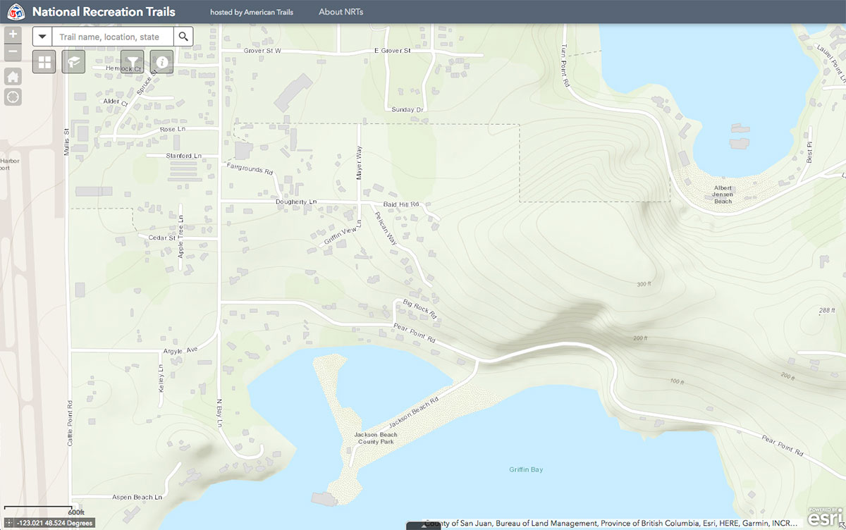
The missing mountain – Click to enlarge
Ever wonder where the name “Missing Mountain Road” came from for the connector road that’s going to be built across the Lafarge Open Space between Turn Point and Pear Point Roads?
I found this map on the National Recreation Trails website a while back. I was looking at something else (I don’t remember what exactly), but I got scrolling around looking at different things and came across this.
Notice that the roads and buildings are all pretty much up to date.
But look at the contours and shading over there at the gravel pit, (now Island Rec’s Lafarge Open Space). That’s Bald Hill at 300 feet elevation – how it stood before the Lafarge gravel company shipped it away via barge after barge on its way to Canada.
Does anyone remember how long that gravel pit was in operation?
You can support the San Juan Update by doing business with our loyal advertisers, and by making a one-time contribution or a recurring donation.
Categories: History
3 comments:
3 comments...
It was Friday Harbor Sand and Gravel long before LaFarge came on the scene, my mom says it was there in the 40s when she arrived and I remember it as child in the early 60s.
From a cartographer’s perspective, the contour lines usually are created from data generated by the Shuttle Radar Topography Mission (SRTM) in 1999/2000 (https://en.wikipedia.org/wiki/Shuttle_Radar_Topography_Mission). But I’m also relatively new to the island so I could be very mistaken.
The County has newer topography data from LiDAR collected in 2009, 2013, and 2019, but these datasets are not as well known as the SRTM and usually are not used by large mapping companies such as Esri and Google.
The recent LiDAR collections can be seen by turning on the respective “Bare Earth” layers in the Layer List tool on the County’s Polaris website (https://sjcgis.maps.arcgis.com/apps/webappviewer/index.html?id=39b87792947e40a5aa0fcb8af5910bd1).
According to “The San Juan Story” by C.T. Morgan, San Juan Island Gravel Pit was originally started in 1957 by Bob Hutton, Roy Gaasband and Charles Hyde. I remember playing in the cove where the barge landing was located before it was built. I never remember that area being referred to as “Missing Mountain”. I’ve talked to several “old timers” and they like me always referred to the area as Bald Hill as did our parents. When the connector road is built it should name Bald Hill.
By submitting a comment you grant the San Juan Update a perpetual license to reproduce your words and name/web site in attribution. Inappropriate, irrelevant and contentious comments may not be published at an admin's discretion. Your email is used for verification purposes only, it will never be shared.